


وصف لـ Trekarta - offline maps for outdoor activities
Trekarta is designed for hiking, geocaching, off-roading, cycling, boating and all other outdoor activities. It uses offline maps so you do not need to have internet connection. You can easily import places and tracks from GPX and KML data formats or create places in application and share them to others. It lets you write the track of your journey, even in background, so you will never get lost and be able later see where you've been.
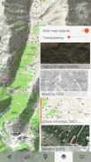
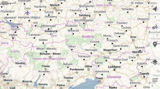
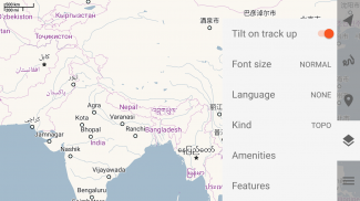
Offline maps
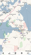
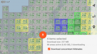
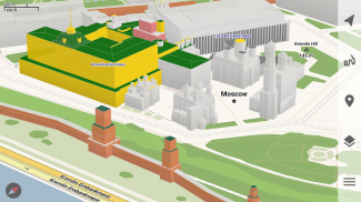
Trekarta uses OpenStreetMap based vector maps that are lightweight, offline and are constantly enhanced by contributors. Maps contain detailed topological data with elevation contours. Some map elements can be filtered out for cleaner look. Trekarta has built-in hillshades support. You can add custom maps in sqlite or mbtiles format to cover your area of interest. Custom maps will be shaded as well. Such maps can be created by yourself with SAS.Planet application from mostly any online source or converted with MapTiler and other applications from other map formats.
Hiking
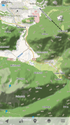
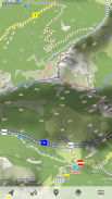
Special hiking activity mode emphasises paths and tracks on map. It visualizes path difficulty and visibility and displays hiking routes. It also displays special OSMC symbols that help you identify desired route.
Skiing and skating
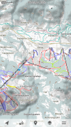
Skiing activity mode displays clean winter map with mostly all skiing activities: downhill, nordic, hiking and touring. As a bonus freestyle snow-boarding, skating and sleighing areas are displayed.
Off-road
Unpaved, dirt, winter and ice roads are specially visualized. 4wd only roads have specific marking. Fords are displayed on all roads, even primary.
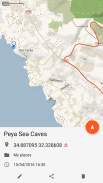
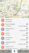
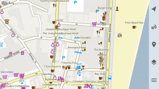
Places
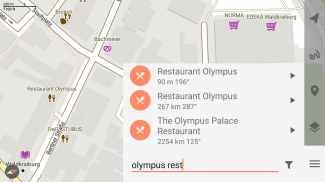
Places can be easily imported from GPX and KML files or can be created within application. You can navigate to places and share them with others.
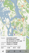
Tracks
Trekarta is designed to record tracks of your journey. Simply press a button when you start and press it once more when you finish. You can quit the application if you do not need to look at the map, the track will be recorded in the background.
Plugins
Trekarta functionality can be extended by plugins. Currently the following plugins are available:
• Location sharing
• Dropbox sync
More info
More information can be found at:
https://andreynovikov.info/tag/trekarta.html
Questions can be asked at:
https://groups.google.com/d/forum/trekarta
تم تصميم Trekarta للمشي لمسافات طويلة ، ورياضة الجيوكاش ، والطرق الوعرة ، وركوب الدراجات ، وركوب القوارب وجميع الأنشطة الخارجية الأخرى. يستخدم خرائط دون اتصال بالإنترنت حتى لا تحتاج إلى اتصال بالإنترنت. يمكنك بسهولة استيراد الأماكن والمسارات من تنسيقات بيانات GPX و KML أو إنشاء أماكن في التطبيق ومشاركتها مع الآخرين. يتيح لك كتابة مسار رحلتك ، حتى في الخلفية ، لذلك لن تضيع أبدًا وستتمكن لاحقًا من معرفة أين كنت.
الخرائط بلا اتصال
يستخدم Trekarta خرائط متجه إلى OpenStreetMap وخفيفة الوزن وغير متصلة بالإنترنت ويتم تحسينها باستمرار بواسطة المساهمين. تحتوي الخرائط على بيانات طوبولوجية مفصلة مع حدود الارتفاع. يمكن تصفية بعض عناصر الخريطة للحصول على مظهر أنظف. Trekarta لديه دعم التلال المدمج. يمكنك إضافة خرائط مخصصة بتنسيق sqlite أو mbtiles لتغطية مجال اهتمامك. سيتم تخصيص خرائط مخصصة أيضًا. يمكن إنشاء هذه الخرائط بنفسك باستخدام تطبيق SAS.Planet من أي مصدر عبر الإنترنت أو تحويله باستخدام MapTiler وتطبيقات أخرى من تنسيقات خرائط أخرى.
المشي لمسافات طويلة
يؤكد وضع نشاط المشي لمسافات طويلة على المسارات والمسارات على الخريطة. يتصور صعوبة المسار ووضوح الرؤية ويعرض طرق المشي لمسافات طويلة. كما يعرض رموز OSMC الخاصة التي تساعدك على تحديد المسار المطلوب.
التزلج والتزحلق
يعرض وضع نشاط التزلج خريطة شتوية نظيفة مع معظم أنشطة التزلج: الانحدار والشمال والمشي والتجول. يتم عرض مناطق التزلج والتزحلق على الجليد كمكافأة حرة.
على الطرق الوعرة
يتم تصور الطرق غير المعبدة والأوساخ والشتاء والجليد بشكل خاص. 4wd فقط الطرق لها علامات محددة. يتم عرض السور على جميع الطرق ، حتى الأولية.
الأماكن
يمكن استيراد الأماكن بسهولة من ملفات GPX و KML أو يمكن إنشاؤها داخل التطبيق. يمكنك التنقل إلى الأماكن ومشاركتها مع الآخرين.
المسارات
تم تصميم Trekarta لتسجيل مسارات رحلتك. ما عليك سوى الضغط على زر عندما تبدأ ثم اضغط عليه مرة أخرى عند الانتهاء. يمكنك إنهاء التطبيق إذا كنت لا تحتاج إلى إلقاء نظرة على الخريطة ، سيتم تسجيل المسار في الخلفية.
الإضافات
يمكن تمديد وظائف Trekarta بواسطة الإضافات. تتوفر الإضافات التالية حاليًا:
• مشاركة الموقع
• مزامنة Dropbox
مزيد من المعلومات
يمكن الاطلاع على مزيد من المعلومات على:
https://andreynovikov.info/tag/trekarta.html
يمكن طرح الأسئلة على:
https://groups.google.com/d/forum/trekarta
Trekarta - offline maps for outdoor activities - إصدار 2023.11
(30-11-2023)
Trekarta - offline maps for outdoor activities - معلومات APK
نُسخة APK: 2023.11الحزمة: mobi.maptrekتطبيقات من الفئة نفسها
قد يعجبك أيضًا...


